Applying Geography to Interpret the Past
CHINA
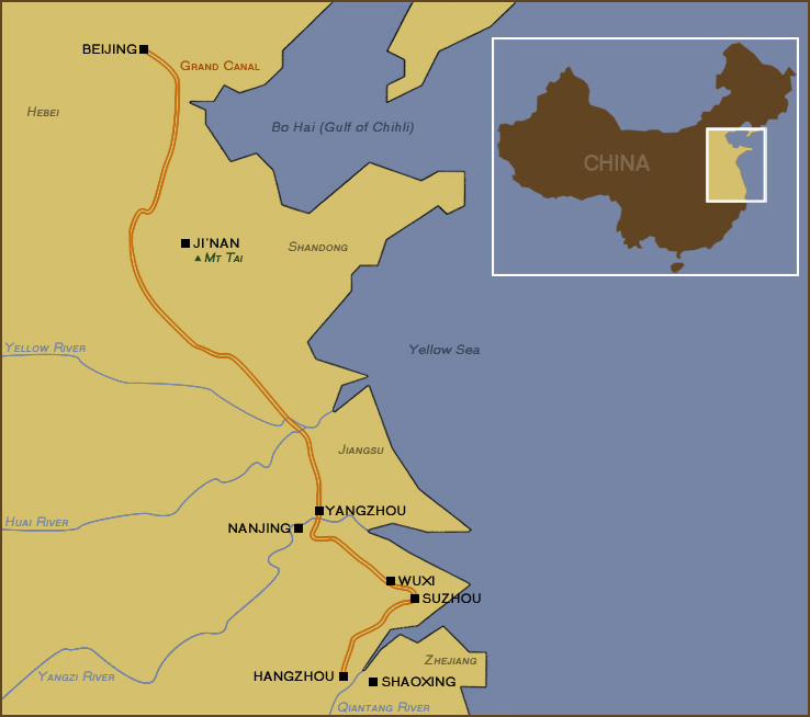
CHINA has major rivers and a long coast line. Why did the Chinese dig the Grand Canal?
Since China's major rivers — the Huang He (Yellow River) and Chang Jiang (Yangzi or Yangtze River)— flow from west to east, and there is no natural communication north to south except by way of a coastal route, the Chinese dug the Grand Canal as a safe, inland water route between the two major rivers, in the process connecting a number of minor regional rivers.
Constructed around 605 AD to serve commercial as well as military considerations, the canal was extended several times, most notably to the Hangzhou in 610 and eventually in 1279 to Dadu, the great Mongol (Yuan dynasty) capital. During the Ming and Qing dynasties, which followed the Mongol dynasty, the Grand Canal ensured that Beijing, the great successor imperial capital to Dadu, had sufficient grain from the southern rice bowl areas.
The Grand Canal is the longest artificial waterway in the world and has a long history of barge traffic along its course. Although many parts of it fell into disrepair over the years, today it is still possible to traverse the manmade Grand Canal from Hangzhou, Zhejiang Province, northward 1,801 km to Beijing.
• The Importance of the Grand Canal during China's Qing Dynasty (1644-1912)
-
To a certain extent, the Qing state itself facilitated the movement of goods to market by locating Beijing, its capital, far to the north, away from the rich and prosperous rice growing areas of Southern China. This resulted in a natural market for the demand of goods in the North, if for no other reason than to feed the imperial household and court. This was one of the reasons why it was so important to keep the Grand Canal working.
The Grand Canal was a major conduit for grain, salt, and other important commodities. Any taxes that were paid in kind were paid in grain, which was shipped along the Grand Canal. Thus, control of the Grand Canal was of critical importance to the Qing government.
-
Arteries of Empire (additional reading) [AFE]
This reading for students discusses China's hydraulic (water control) system and important improvements over time in canal transport. The reading can be used to enlarge the discussion of the Grand Canal and China's use of waterways.
Questions For Discussion:
Why do you think the Chinese built the Grand Canal?
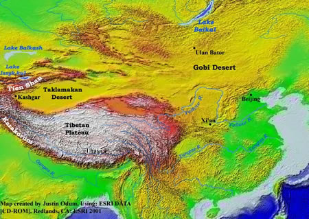
Looking at a map of China (below), take into consideration the following:
- Was it easy to move goods over roads in early history?
- Which directions do the rivers flow in China?
- How big an area was involved in "China" of early history?
- What are the pros and cons of shipping and moving by sea?
- Can the Grand Canal still be used today?
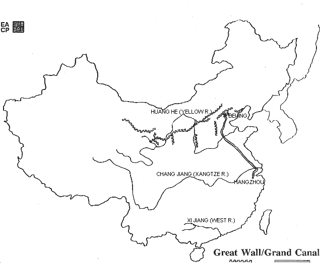
Why did the Chinese build the Great Wall?
Questions for Discussion:
Looking at the maps below, see if you can solve this mystery:
- Why do you think the Chinese only built a wall in the north of China for protection?
- Why didn’t they feel they needed protection on the west, south, or east?
- Was the geographical terrain different in those directions? (SEE second, topographical map below as well.)
Why is such an important, ancient city as CHINA's Chang'an (Xian, today) located at the beginning of the desert in western China?
- Chang'an (or Xian, as it is known today) was the capital city of early Chinese dynasties. Chang'an was also a "terminus" of the trading routes between China and points to the west of China. These trading routes were collectively called “the Silk Road.”
See also: The Silk Road section.
- Xian (additional reading) [University of Maine]
A reading about Xi'an and its history. Includes discussion of the city, of the neolithic village of Banpo, the tomb warriors, the Silk Road, Buddhism, the Ming walls, bell and drum tower, and Xi'an today. With photographs.
Questions for discussion:
Looking at the map of eastern Asia's topography (above), can you give two reasons why Chang'an was both a capital city and the terminus of the Silk Road?
Looking at the map of downtown Xi'an today (below), you will see both a "great mosque" and a Buddhist pagoda. How do these reflect the geographic position of Xi'an/Chang'an as a terminus for trade routes to areas west of China?
BONUS: Research the history of some of Xian’s monuments: see Xi'an
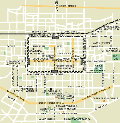 Map of Downtown Xi'an [TravelChinaGuide.com]
Applying Geography to Interpret the Present and Plan for the Future
Since China's major rivers — the Huang He (Yellow River) and Chang Jiang (Yangzi or Yangtze River)— flow from west to east, and there is no natural communication north to south except by way of a coastal route, the Chinese dug the Grand Canal as a safe, inland water route between the two major rivers, in the process connecting a number of minor regional rivers.
Constructed around 605 AD to serve commercial as well as military considerations, the canal was extended several times, most notably to the Hangzhou in 610 and eventually in 1279 to Dadu, the great Mongol (Yuan dynasty) capital. During the Ming and Qing dynasties, which followed the Mongol dynasty, the Grand Canal ensured that Beijing, the great successor imperial capital to Dadu, had sufficient grain from the southern rice bowl areas.
The Grand Canal is the longest artificial waterway in the world and has a long history of barge traffic along its course. Although many parts of it fell into disrepair over the years, today it is still possible to traverse the manmade Grand Canal from Hangzhou, Zhejiang Province, northward 1,801 km to Beijing.
To a certain extent, the Qing state itself facilitated the movement of goods to market by locating Beijing, its capital, far to the north, away from the rich and prosperous rice growing areas of Southern China. This resulted in a natural market for the demand of goods in the North, if for no other reason than to feed the imperial household and court. This was one of the reasons why it was so important to keep the Grand Canal working.
The Grand Canal was a major conduit for grain, salt, and other important commodities. Any taxes that were paid in kind were paid in grain, which was shipped along the Grand Canal. Thus, control of the Grand Canal was of critical importance to the Qing government.
This reading for students discusses China's hydraulic (water control) system and important improvements over time in canal transport. The reading can be used to enlarge the discussion of the Grand Canal and China's use of waterways.
Why do you think the Chinese built the Grand Canal? Looking at a map of China (below), take into consideration the following:
- Was it easy to move goods over roads in early history?
- Which directions do the rivers flow in China?
- How big an area was involved in "China" of early history?
- What are the pros and cons of shipping and moving by sea?
- Can the Grand Canal still be used today?
Looking at the maps below, see if you can solve this mystery:
- Why do you think the Chinese only built a wall in the north of China for protection?
- Why didn’t they feel they needed protection on the west, south, or east?
- Was the geographical terrain different in those directions? (SEE second, topographical map below as well.)
See also: The Silk Road section.
A reading about Xi'an and its history. Includes discussion of the city, of the neolithic village of Banpo, the tomb warriors, the Silk Road, Buddhism, the Ming walls, bell and drum tower, and Xi'an today. With photographs.
Looking at the map of eastern Asia's topography (above), can you give two reasons why Chang'an was both a capital city and the terminus of the Silk Road?
Looking at the map of downtown Xi'an today (below), you will see both a "great mosque" and a Buddhist pagoda. How do these reflect the geographic position of Xi'an/Chang'an as a terminus for trade routes to areas west of China?
BONUS: Research the history of some of Xian’s monuments: see Xi'an
Map of Downtown Xi'an [TravelChinaGuide.com]"Geography is for life in every sense of that expression: lifelong, life-sustaining, and life-enhancing," declares the executive summary for the National Geography Standards.
While this website focuses on East Asia — China, Japan, Korea, and Vietnam — it is inevitable that linkages, interconnections, and issues arise for both teacher and student that course across Earth space as well as chronologic time at various scales, ranging from the personal to the truly global.
In terms of acquiring and mastering knowledge, skills, and perspectives, the path to geographic competency leads to increasing understanding of complex issues such as cooperation and conflict, international trade, human migration, economic development, energy interdependence, ecosystem stress, biodiversity, consumerism, natural disasters, sustainability, among a host of other contemporary themes that cannot be confined within the boundaries of a single nation or region.
Whether looking at the countries of East Asia in the past or the present, our goal is to understand them as they and the rest of the world moves toward the future.
World in the Balance [NOVA, PBS]
NOVA examines the various threats facing human populations and national economies in terms of the environmental implications of countries undergoing industrialization as well as global climate change. Employing sophisticated graphics, including vivid interactives, the website includes much content relating to East Asian countries.