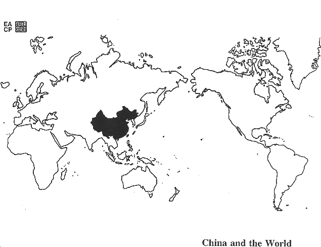
China's Geography with Maps
The consultant for this unit was Professor Ronald G. Knapp, Distinguished Professor Emeritus at SUNY New Paltz ...see more.
Maps
These maps are discussed in the sections below. Note that some of the outline maps included below are designed to be used as transparencies that can be overlaid on an overhead projector to demonstrate the diversity of China's physical and cultural geography.
Overlays for Classroom Use
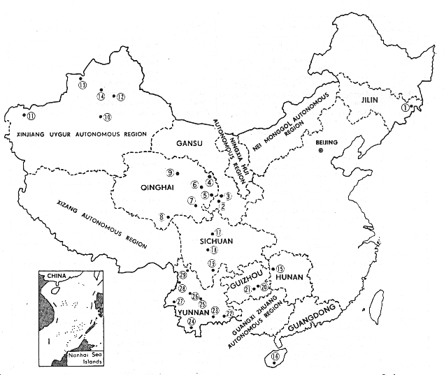
Geographic Distribution of China's National Minorities
1. Yanbian Korean Autonomous Prefecture
2. Gannan Tibetan Autonomous Prefecture
3. Linxia Hui Autonomous Prefecture
4. Haibei Tibetan Autonomous Prefecture
5. Huangna Tibetan Autonomous Prefecture
6. Hainan Tibetan Autonomous Prefecture
7. Guoluo Tibetan Autonomous Prefecture
8. Yushu Tibetan Autonomous Prefecture
9. Haixi Mongolian, Tibetan, Kazakh Autonomous Prefecture
10. Bayingolin Mongolian Autonomous Prefecture
11. Kizilsu Khalkhas Autonomous Prefecture
12. Changji Hui Autonomous Prefecture
13. Bortala Mongolian Autonomous Prefecture
14. Ili Kazakh Autonomous Prefecture
15. Xiangxi Tujia, Miao Autonomous Prefecture
16. Haina Li, Miao Autonomous Prefecture
17. Aba (Ngawa) Tibetan Autonomous Prefecture
18. Garze Tibetan Autonomous Prefecture
19. Liangsha Yi Autonomous Prefecture
20. Qiandongnan Miao, Dong Autonomous Prefecture
21. Qiannan Bouyei, Miao Autonomous Prefecture
22. Wenshan Zhuang, Miao Autonomous Prefecture
23. Honghe Hani, Yi Autonomous Prefecture
24. Xishuangbanna Dai Autonomous Prefecture
25. Chuxiong Yi Autonomous Prefecture
26. Chuxiong Yi Autonomous Prefecture
27. Dehong Dai, Jingpo Autonomous Prefecture
28. Nujiang Lisu Autonomous Prefecture
29. Degen Tibetan Autonomous Prefecture
Population
It is a well known fact that China is the most populous nation in the world (although India may soon surpass China in total population). China's total population in 2020 was 1.4 billion people (1,400,000,000). This exceeds the combined populations of Europe, South America, the United States, and Japan! Certain Chinese provinces are more populous than European countries.
- By comparison, the population of the United States in 2020 is 331,000,000 (or 331 million).
- China's population is roughly equivalent to 4x that of the United States.
Population and Land Area
Such a huge population imposes substantial stress on the country's natural resources, including especially arable land.
- Although China ranks fourth in the world in terms of total arable land, the pressure of population on this precious available agricultural land is acute and makes China's struggle to increase its agricultural output to feed its population all the more difficult.
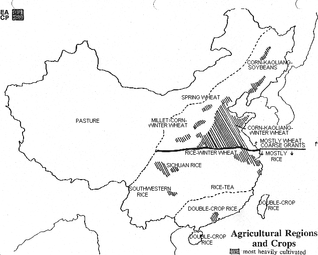
- Looking at the map of China's agricultural regions and crops, you will see that China's arable land is primarily in the eastern region, the same area where a majority of China's vast population is concentrated.
- In addition to extensive areas of western China which are relatively uninhabited, substantial portions of southern China are unfavorable for agriculture because of mountainous topography.
- There are significant variations from province-to-province in terms of cultivated land, multiple-cropping, and overall production of various crops.
China feeds somewhat less than one-fifth (20%) of the world's population on approximately 9% of the world's arable land.
U.S. China Comparison
Land Area
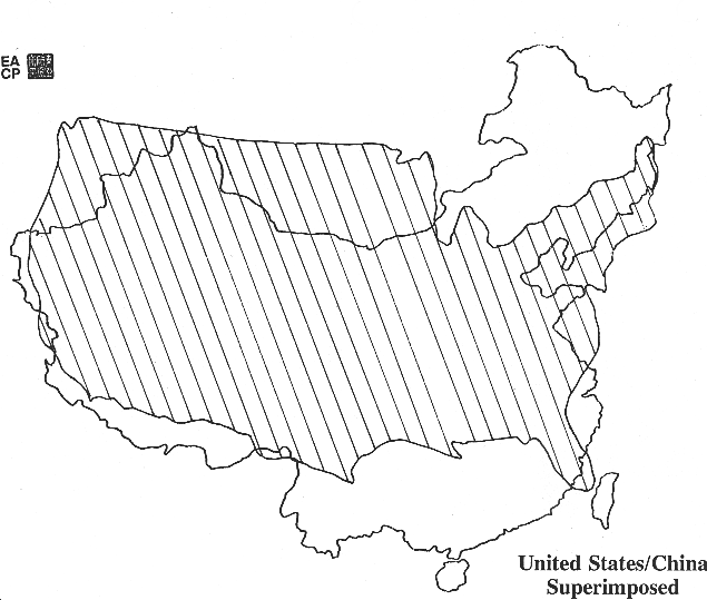
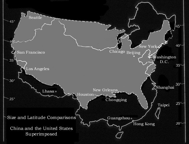
Viewing the map showing the U.S. and China superimposed, it can be seen that China has only a slightly larger land area, 3.69 million square miles compared to the 3.68 million square miles of the United States. However, while approximately 40% of the U.S. land can be cultivated, only 10% of China's land is arable. Much of the arable land in the United States, of course, is actually not used for farming but instead is used for pasture or has been developed for other uses.
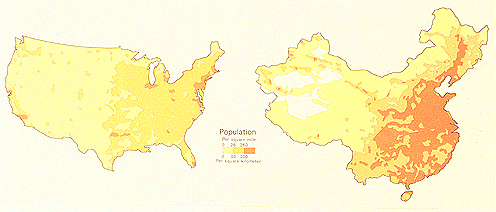
Population Density
Like China, the U.S. has a densely populated east coast. Unlike the U.S., however, China's farmland is not concentrated in a relatively underpopulated central section of the country. The following map compares the densities of population in the United States and China:
United States and China: Comparative Population DensityEthnic Composition of China's Population
China population is composed of over 50 ethnic minorities. The vast majority of the population belong to the Han ethnic group, residing in the eastern region of China. A map showing the geographical distribution of various national minorities in China is here. Population statistics on the official ethnic groups and other materials are here.
Borders
Early Civilizations
Looking at the map of historical borders and the map showing the major rivers highlights the important fact that the earliest hearths of Chinese civilization developed along its river valleys.
- One of the cradles of Chinese civilization, the Neolithic site called Banpo, was located along a tributary of the Huang He not too far from the present-day city of Xi'an in Shaanxi province.
- Hemudu, on the southern shores of Hangzhou Bay that lies to the south of the Yangzi River delta, is another of China's important Neolithic sites.
- The Shang dynasty (c. 1600-1027 BC) was also situated around the Huang He (Yellow River), and eventually spread southward to the Chang Jiang (Yangzi River) and Xi Jiang.
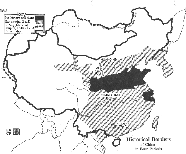
Historical Borders
Like many other countries, the historical borders of china have varied over time.
- Under the Han dynasty (202 BC-202 AD), China's great historical empire, these early boundaries were significantly expanded, as the map of the historical borders of China shows.
- The extent of China's territory was greatest under the last dynasty, called the Qing (Ch'ing) or Manchu dynasty between 1644-1912. China's territory was more extensive under the Qing empire than it is today.
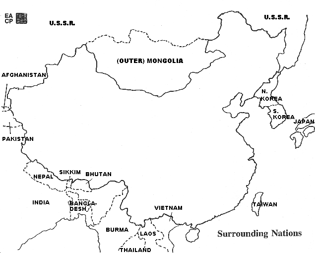
Bordering Nations
Looking at the map of bordering nations, it is possible to identify China's neighbors
- China is at the core of a cultural sphere or region known as East Asia. China, Korea, Japan, and Vietnam historically form the East Asian or Sinitic (Chinese) cultural sphere.
- The large number of countries with which China shares borders makes Chinese foreign policy with its bordering nations more complex than countries such as the U.S., for example which shares borders only with two countries, Canada and Mexico).
Regions
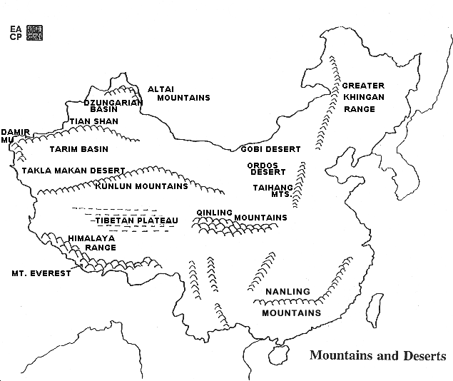
The cross-hatching nature of China's five mountain ranges, the step-like staircase decrease in elevation from the lofty Tibetan plateau towards the sea, and the location of rivers make for a number of distinct geographical regions that fall into a checkerboard composition of basins, plateaus, and plains. Note the problems these pose for political and economic unity on the overlays of mountains and deserts and rivers.
Western and Eastern Regions
For the sake of elementary convenience, the landmass of China can be divided into two basic components:
- A vast Western region occupying nearly 2/3 of the country that is generally too high, too cold, and/or too dry to support a dense agricultural population. Much of this higher western area occupies the two upper steps of the topographic staircase:
- Qinghai-Tibetan plateau, sometimes known as the "roof of the world" with average elevations above 4000 meters and
- a broad arc-like step running northeast/southwest from the grasslands of the Inner Mongolian steppes through the deserts and basins of Xinjiang to the Yunnan-Guizhou plateaus of southwestern China.
- An Eastern region occupying 1/3 of the country — that portion of China east of the Tibetan Plateau and generally south of the Great Wall — forming the core of “China Proper.â€
- It is framed on the west by mountain ranges about 1000 meters in elevation — Greater Khingan, Taihang, Wushan, and Xuefeng — and includes the densely settled North China Plain along the lower course of the Huang He and numerous plains in the middle and lower reaches of the Chang Jiang
- It is customary to include Northeast China, often still referred to as Manchuria, in this Eastern region.
- Northern and Southern China. This diverse region includes the eighteen traditional provinces of imperial China, and can be divided into Northern China and Southern China with the Qinling Range and Huai River forming the natural zone of demarcation between them.
Interregional Trade
A benefit of China's varied geography is that a shortage of resources in one part of China can be overcome by trade with another part. In this way China historically has been able to develop internally by promoting interregional trade, as opposed to going outside the country as many smaller European countries had to do. Instead of industrializing to overcome shortages, China traded within its own borders, thus promoting commercial development.
A shortage in labor in one area could similarly be filled by migration within the country or by shifting manufacturing to another area.
- Geographic factors that facilitated this internal trade were the Chang Jiang (Yangzi River), the complex network of rivers in the south, and China's long coastline.
- China thus did not feel great pressure to develop labor-saving technologies or to engage in extensive expansionist or colonizing activities beyond its borders, in contrast to the West and Japan. (This contrasts markedly with the political and economic history of Europe, where the existence of many small countries led to trade barriers and local shortages, prompting individual countries to make technological advances and wage costly wars that contributed to the rise of large financial empires and engage in expansionist imperialism.)
Disparity among Regions
A recurrent problem, however, is that some regions in China have developed more quickly than others because of their location. For example,
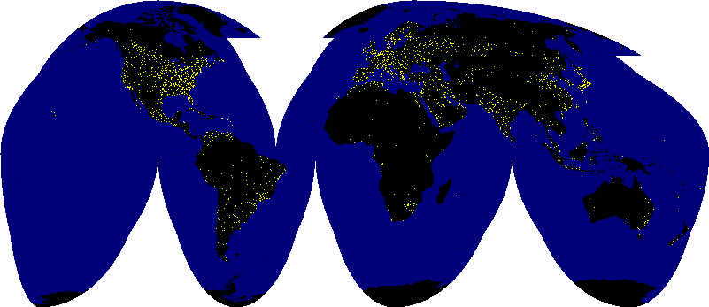
- the coastline of China with its ports and fertile soil has developed more rapidly than western China with its deserts and mountains.
- Western China is more isolated and thus lags behind the coastal regions, a condition that can be seen clearly in this view of the Earth at night where only lights and fires are visible.
Political Divisions
The People's Republic of China has 34 major political divisions (Although the PRC considers Taiwan to be one of its provinces, Taiwan remains politically separate as the Republic of China).
- 23 provinces
- 4 municipalities — Beijing, Shanghai, Tianjin, and Chongqing. Because of their size and other characteristics, these four cities have been given provincial-level status and report directly to the central government.
- 5 autonomous regions. The title "autonomous region" indicates that a substantial proportion of the population in the region is composed of minority nationality peoples whose language, culture, and particular social traits are distinct from the dominant Han culture; for the sake of political unity, the regions are given special consideration by Beijing in policy formulation. The regions are otherwise not "autonomous." (Eight percent of China's population is composed of minority nationality peoples. There are 55 distinct minority nationalities in China) A crucial factor is that these minority nationalities occupy 50-60% of Chinese territory” most notably Xinjiang (where China's nuclear installations are located), Mongolia, and Tibet. These facts are useful in highlighting the difficulties entailed in ruling such a vast country. (See attached map and list on China's minority nationalities)
- Special Administrative Region (SARs). Hong Kong gained this status on July 1, 1997 when it ceased being a British Crown Colony. Macao, once a colony of Portugal, reverted to Chinese sovereignty on December 20, 1999 and became the country's second SAR.
Geographcal Features
Mountains, Deserts, Plateaus: Was China Isolated in History?
- The west of China is comprised of mountains and deserts as well as plateaus that do not provide much arable land for agriculture.
- Throughout most of history, the civilization that grew up to the east in what is today China was not surrounded by other nearby major civilizations. To this extent the Chinese were "isolated" from competing civilizations.
- There was a broad and fluid frontier zone on the western margins.
- Notably, invasions of China in history came from the northern area and were invasions over land. (See more on the Great Wall below, under 'Supplementing Geography.') This geographical fact is important to remember when discussing the Western encroachment on China from the sea during the late imperial period.
- Although the mountains and deserts of the west limited contact between early imperial dynasties and other centers of civilization in the Inner Asia, Middle East, South Asia, and Europe, there were some important and notable exchanges of culture. The legendary Silk Road facilitated the exchange of goods and ideas between China and each of these areas, from the Han dynasty (206 BCE-220 CE) through to the Ming dynasty in the 1400s CE.
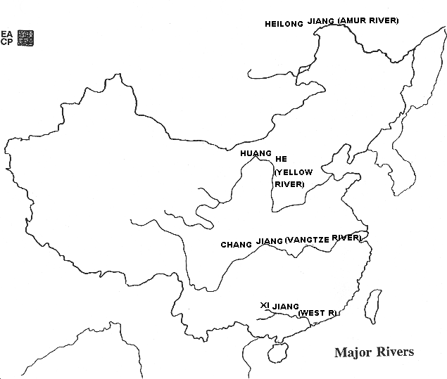
Rivers
Major Rivers
China's two major rivers, the Huang He (Yellow River) and the Chang Jiang (Yangzi or Yangtze River), as well as the Pearl River (Zhu Jiang) delta system marked by the Xi Jiang (West River) in southeastern China, have provided the framework for agricultural development and population growth throughout China's history.
- Another river, the Heilong Jiang (known also as the Amur River, its Russian name) marks the border between China and Russia; at times in the past, this area was one of confrontation between the neighbors.
- The drainage basins of China's rivers differ in terms of extent and topography, offering varying opportunities for agricultural development. Because some of China's largest rivers have their source regions on the high Qinghai-Tibetan Plateau and drop great distances over their middle and lower courses, China is rich in hydroelectric resources.
Words for 'River' in Chinese
Each of these rivers has special characteristics and associated problems at different locations along their courses.
- Note that "he" and "jiang" are both translated into English as "river."
- In English, there are of course many words that differentiate flowing water according to size and character — stream, brook, creek, river, just for a couple of examples.
- In the Chinese language, similar differences are expressed but the common words usually translated into English as "river" can be further clarified somewhat.
- "Jiang" is the most common descriptor for "river" in Chinese, signifying a stream that is often geologically young which cuts through a narrow valley. The middle and upper sections of the Chang Jiang resemble the unruly Colorado River
- "He", on the other hand, is generally used for a river that is broad and geologically old. In this regard, much of the lower course of the Huang He is reminiscent of the sluggish Mississippi River.
- It is thus redundant to say Huang He River or Chang Jiang River.
Huang He (Yellow River)
Huang He (Yellow River). China's second longest river, the 'Huang He' rises in Qinghai province and flows some 5464 km to the Yellow Sea.
- Crystal clear lakes and sluggish meandering are characteristic in its upper reaches.
- Along the Great Bend of the Huang He in its middle course, the unruly river carves its way through the loessial plateau with substantial erosion taking place.
- As the river erodes the loess, it becomes a "river of mud" (Loessial soil is called 'huang tu' or "yellow earth" in Chinese and it is the color of this suspended loess in the river that has given the Huang He its name "Yellow River.")
- Carrying 40% sediment by weight in summer (for other rivers in the world 3% would be considered a heavy sediment load), the river deposits vast amounts of alluvium as it courses across the North China Plain.
- Over the centuries, deposition has raised the bed of the Huang He so that it is in some ways "suspended" precariously above the lower surrounding agricultural areas, contained by levees and embankments built to control what historically was "China's Sorrow" —the bringer of flood and famine.
- Throughout the loessial uplands, some 40 million Chinese still live in cave-like or subterranean dwellings that are an especially appropriate response to the peculiar nature of loess and the absence of alternative building materials such as timber.
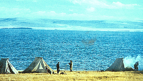 Upper Reaches of Huang He in Qinghai
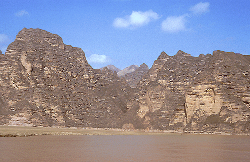 Tawny Loessial Cliffs along Huang He in Gansu
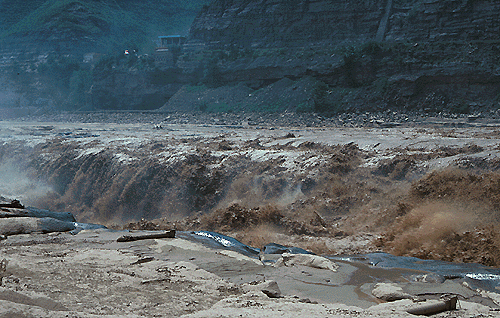 Unruly Huang He at Hukou on the Shanxi / SHaanxi Border
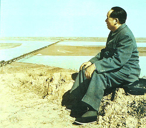 Chariman Mao surveys the Lower Qinhai
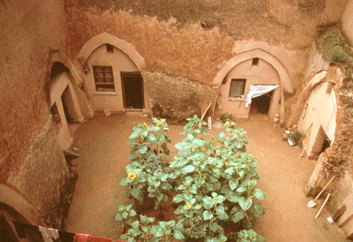

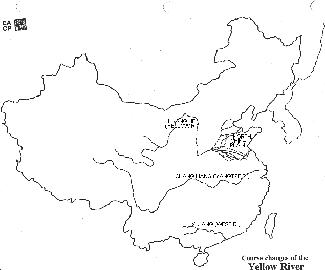
Course Changes of the Huang He
The lower course of the Huang He has changed 26 times in China's history, most notably nine times including major floods in 1194 AD and again in 1853, that brought untold disaster to the villages and towns of the North China Plain. (See Map of Course Changes of the Huang He.) What was once a scourge that plagued the Chinese people throughout much of their history continues to be one of China's great natural challenges, preventing both flooding and drought in a region with more than 100 million people.
- Siltation at the mouth of the Huang He extended the length of the river by about 35 km (20 miles) between 1975 and 1991.
- The North China Plain is indeed a "gift" of the Huang He.
Role of the Chinese Emperor in “Controlling the Floods†throughout History
As the guardian of the population's welfare, one of the important roles for the emperors of China throughout dynastic history was that of water control. Throughout history management of the empire's vast network of rivers, canals, and irrigation systems has been a fundamental task of China's rulers, while the threat of floods has been the greatest threat to economic and political stability.
A beautiful picture scroll, painted by an artist accompanying the Qianlong Emperor's first southern inspection tour of 1751 depicts the emperor looking over the confluence of the muddy, yellow waters of the Yellow (Huang) River and the clear waters of the Huai River, which was the critical point in the entire water control network of Southern China.
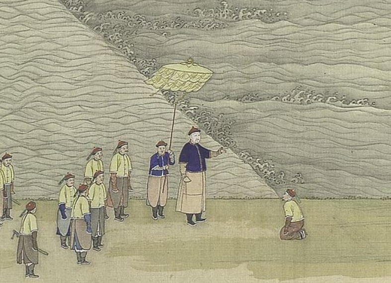
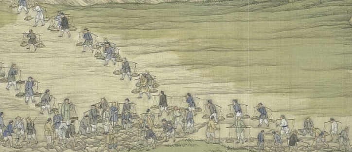 Workers digging up the dike at the Huang-Huai confluence, from The Qianlong Emperor's Southern Inspection Tour, Scroll Four: The Confluence of the Huai and Yellow Rivers, 1770
- Until 1860 the Yellow River flowed south of the Shandong Peninsula toward the ocean, and before reaching the ocean, merged with the Huai River.
- That point of convergence was the place where flooding was most likely to occur, for the Yellow River carried so much silt that it was constantly filling up the river bed and was prone to overflowing its boundaries.
- Flood prevention here was essential, for if the Yellow River overflowed, it would flood much of the arable land in Southern China.
- Thus, the confluence of these two rivers was the center of a great deal of attention throughout the Qing dynasty, and enormous stone dikes and a number of complex waterways were built during this time to prevent flooding in this area.
- The Chinese government continues to monitor this area with dams and water control in the 21st c.
Chang Jian (Yangtze River)
Chang Jiang (Yangzi River). As China's "main street," this artery courses over 6300 km through several of China's most economically developed regions.
- Excellent river ports — Shanghai, Zhenjiang, Nanjing, Wuhan, Yichang, and Chongqing — are located near or along the Chang Jiang, making it one of the world's busiest inland waterways.
- As much of 40% of the country's total grain production, 70% of the rice output, and more than 40% of China's population are associated with its vast basin that includes more than 3,000 tributaries.
- The flow of the Chang Jiang is some 20 times greater than that of the Huang He. With its numerous tributaries, the Chang Jiang drains nearly 20% of China's total area. Its upper reaches tap the uplands of the Tibetan Plateau before sweeping across the enormous and agriculturally productive Sichuan Basin that supports nearly 10% of China's total population.
- It is in the middle course of the Chang Jiang that the Chinese government constructed the controversial Three Gorges Dam.
Three Gorges Dam
The construction of the dam began in 1994 and was completed in 2006. It is a huge public works project — the largest dam in the world, rivaling the building not only of China's great historical projects such as the Grand Canal and Great Wall as well as modern projects elsewhere in the world.
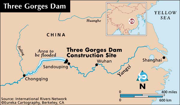
- The Three Gorges Dam project has been wrapped in environmental, engineering, and political controversy since its inception.
- Increasing clean energy, controlling floods, and stimulating economic development are but a few of objectives of the dam.
- Below the Three Gorges Dam are the great flood plains of the Chang Jiang as well as the major tributaries on its north and south banks. At the mouth of the river is the great and productive Yangzi delta and metropolitan Shanghai.
- Prior to the dam's completion, the second worst flood of the past 130 years struck the Chang Jiang valley in summer 1998 and affected 240 million people, killing some 3656, and leaving 14 million homeless. The flood is estimated to have left 14 million people homeless, destroying 5 million houses, damaging 12 million houses, flooding 25 million hectares of farmland, and causing over US$20 billion in estimated damages.
- With the completion of this project, disastrous floods were expected to be eliminated.
- In June 2020, floodwater from reservoirs in the Yangtze river basin in China was discharged after excess rain at the onset of the monsoon. These measures were taken to regulate the flow of water after the excess rain pushed water levels in China's rivers and lakes to record levels, leading to floods that displaced millions within the Yangtze River basin itself.
- Continuous adjustments were made by dam operators to the water outflow from the reservoirs at the time of flooding. Water level went up to a record 164.18 m in the Three Gorges Dam July 19, according to the Three Gorges Corporation that runs the dam. The previous high level was at 163.11 m, during the flood season, since the dam became fully operational in 2012.
- The Yangtze — winding 6,300 kilometres through China — is Asia's longest river. The river, along with its network of lakes and tributaries, is used to generate power, control flooding and store water for drinking and irrigation. Floodwater was held or ‘absorbed’ by more than 2,297 reservoirs in the region — including one behind the Three Gorges Dam — this year. There are now tens of thousands of reservoirs in the region, with numerous dams across the river.
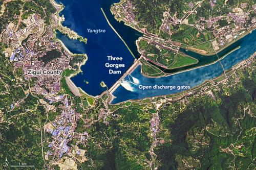 Satellite image of the Three Gorges Dam spilling water. Photo: NASA Earth Observatory / Joshua Stevens
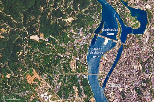 Water flowed from the Three Gorges dam to the smaller Gezhouba Dam, 26 km southeast. Photo: NASA Earth Observatory / Joshua Stevens
- The images above were captured using NASA's Operational Land Imager on its Landsat 8 satellite and are composites of shortwave infrared and natural color to distinguish the water.
- The images were acquired during the first major flooding of the monsoon. A second wave of flooding, referred to as the 'No. 2 flood' by local media, hit the region in July.
- Images acquired on June 30 revealed the spillway gates of the Three Gorges Dam and the Gezhouba Dam were open. Water was seen moving through the gates of the Three Gorges Dam 2,300 metres long and 185 m high to the smaller Gezhouba Dam, around 26 kilometres southeast. (The water around the spillway gates of the dam appears to be whiter because of the way downstream water reflects light.)
Zhu Jiang (Pearl River) Delta
Zhu Jiang (Pearl River) Delta. Situated in Guangdong province just to the north of Hong Kong and Macao, the delta of the Zhu Jiang is the most significant farming area in southeastern China.
- Some regard it as one of the most productive and sustainable ecosystems in the world because of its integrated dike-rice paddy-fish pond agricultural system.
- Between 1988 and 1995, land reclamation along the banks of the river and along the coast added farm land and space for fish ponds as well as created space for rapidly expanding settlements.
Supplementing Geography
The Chinese attempted to correct perceived "deficiencies" in their physical geography by building massive civil engineering projects that would help bring about unity and provide defense as well as by countless smaller scale efforts at modifying their physical landscapes.
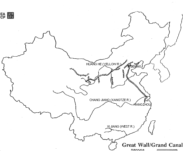
Great Wall
What is known today as the Great Wall (see map of the Great Wall and the Grand Canal) was reputedly first completed during the Qin (Ch'in) dynasty (221-206 BC) when segments of the wall existing from earlier periods were connected. Early walled ramparts were constructed of rammed or tamped earth.
- The brick-faced walls seen today were built much later during the Ming dynasty (1368-1644).
- Although not a single continuous wall, the Great Wall and its associated military encampments and guard posts figured in attempts by many dynasties to manage the nomadic peoples, sometime referred to as "barbarians," who lived north of it on the grasslands or steppes. For the most part, the Great Wall should be viewed as a zone of transition rather than a fixed border between farming areas with sedentary villages and pasture lands with nomadic lifestyles.
Grand Canal
Since China's major rivers the Huang He and Chang Jiang flow from west to east and there is no natural communication north to south except by way of a coastal route, the Chinese dug the Grand Canal as a safe, inland water route between the two major rivers, in the process connecting a number of minor regional rivers.
- Constructed around 605 AD to serve commercial as well as military considerations, the canal was extended several times, most notably to the Hangzhou in 610 and eventually in 1279 to Dadu (today, Beijing), the great Mongol (Yuan dynasty) capital.
- During the Ming and Qing dynasties which followed the Mongol dynasty, the Grand Canal ensured that Beijing, the great successor imperial capitals to Dadu, had sufficient grain from the southern rice bowl areas.
- The Grand Canal is the longest artificial waterway in the world and has a long history of barge traffic along its course.
- Although many parts of it fell into disrepair over the years, today it is still possible to traverse the man-made Grand Canal from Hangzhou, Zhejiang Province northward 1801 km to Beijing.
Terracing and Irrigation
At least as significant as major engineering works like the Grand Canal and the Great Wall are the countless alterations of China's physical landscapes by centuries of human effort. These human modifications traditionally focused on terracing hill slopes and controlling water via irrigation as well as reclaiming marginal land. In managing natural resources and expanding opportunities for the production of food, the Chinese have reclaimed, even created, land that in many areas of the world would have been considered impossible to farm.
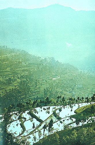
Creating level land through terracing of hill slopes
Throughout the rugged areas of northern and southern China, farmers over the centuries have sculpted the hilly land into step-like landscapes of terraces. Sometimes terraces are relatively natural features that need only be modified in order to produce level areas for planting, while in others extraordinary efforts must be carried out to move earth and rock, stabilize retaining walls, and create sluices for controlling the flow of water. Drainage control and water storage are as important as the level land itself.
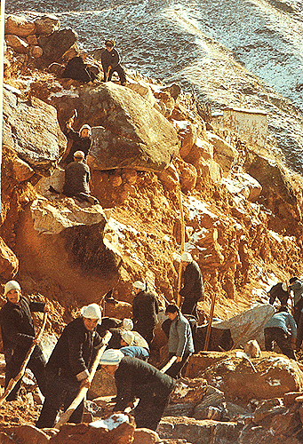 Leveling the Taihang Mountains, Shanxi
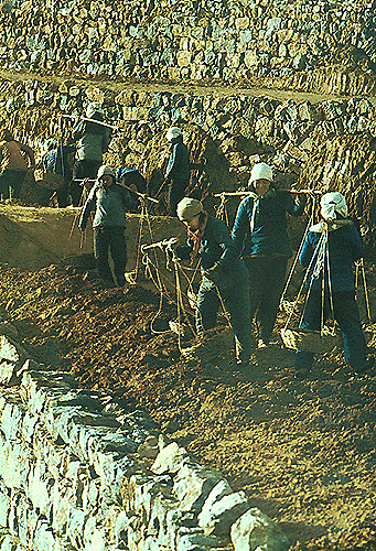 Making Terraces, Dazhai Shanxi
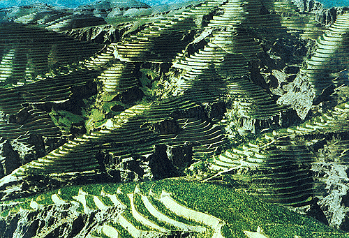 Contoured Terraces, Wubao, Shaanxi
Managing water resources in order to reduce erosion and make water available for terraced rice production
Seen from the air, much of China glistens with countless water surfaces that have been created by human labor.
- The building of terraces on slope land not only creates level land but also provides a means of "managing" rainwater by controlling its runoff.
- As rain falls on hill slopes, it tends to erode them relatively easily, but when the velocity of the water is slowed because it is impounded in irrigated fields erosion is reduced.
- The impounded water then can be controlled as it flows gently from a higher level to a lower level. As water falls from level terrace to terrace, the speed with which the water flows beyond the fields, where it is needed, is minimized.
- Usually fine silt is suspended in the flowing water that then is deposited in the lower fields rather than being carried farther away.
- Besides the obvious irrigation systems that are fundamental to terraced rice production, other systems control water flow and drainage on adjacent paddy fields that are nearly at the same level. Small-scale and large-scale water conservancy projects continue to be important means of increasing crop production as well as reducing flood and drought.
 Jiange, Sichuan
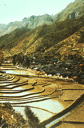 Fenghuang, Hunan
Agriculture
The production of grain accounts for some 80-90% of all agricultural crops in China. Rice, wheat, corn, barley, and millet are the principal grain crops, each of which represents a particular adaptation to specific environmental conditions.
- Wet rice or paddy rice agriculture is carried out particularly in fertile areas of southern and central China where a mild climate favors two and sometimes three crops per year.
- The growing of rice is frequently rotated with other crops such as winter wheat, sweet potatoes, corn, and vegetables of various types.
- Vegetable oil producing plants — specifically rape-seed (the oil of which is known in the U.S. as canola oil), peanuts, and sesame — are widely grown throughout this region on appropriate soils.
- In addition to relatively mild winter temperatures and a long growing season, heavy and predictable summer monsoon rains and overall sufficient annual rainfall are the basis for substantial productive agriculture.
- It is important to recognize that China's southern and central rice-growing regions are quite diverse.
Wet Rice Agricultural Cycle
Briefly explained, wet rice agriculture is an intensive farming system in which dense populations and the intensive use of the earth are complementary.
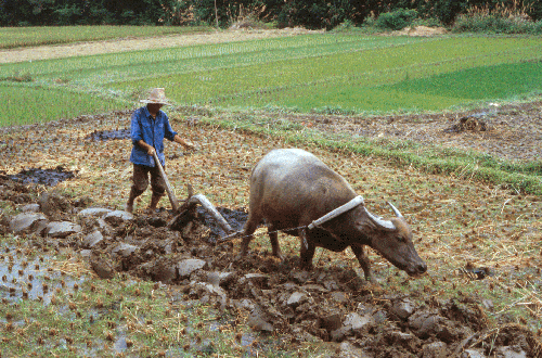 Preparing the Fields: Plowing
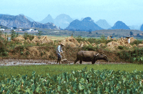 Preparing the Fields: Harrowing
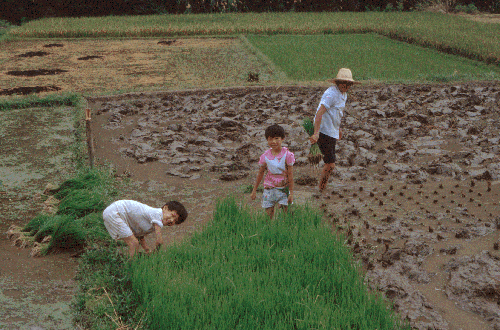 Rice Seedlings in the Seedbed
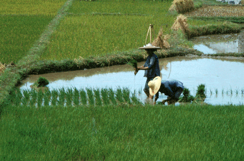 Transplanting the Rice Seedlings
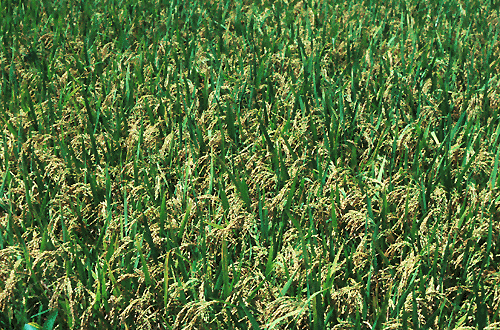 Rice Ready to be Harvested
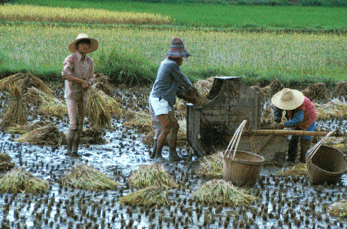 Harvesting the Rice
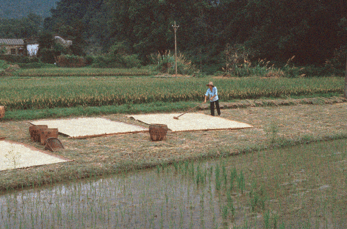 Drying the Rice
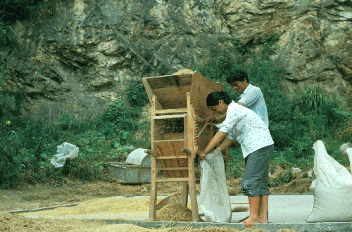 Winnowing the Rice & Preparing to Store It
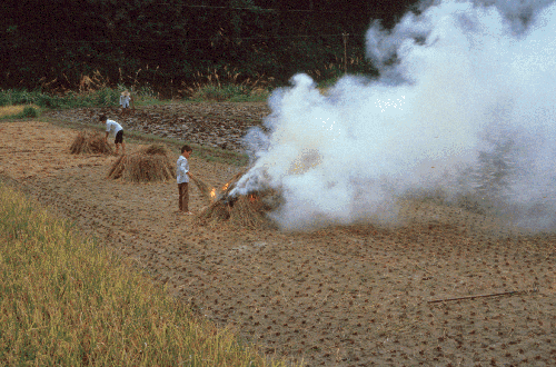 Burning the Rice Plants & Preparing the Fields for Another Crop
- Rice seeds are sown broadcast in seedbeds where the densely packed seedlings are allowed to grow for approximately a month before being transplanted into fields.
- The preparation of fields by plowing and harrowing is labor intensive activity as is the transplantation process.
- Water must be moved on and off the planted areas according to a schedule
- On-going weeding is carried out to insure maximum yields.
- Harvesting and the preparation of the rice for storage are additional labor intensive activities requiring more people.
Although some mechanization of the process of rice production has occurred over the centuries, the production of paddy rice continues to involve the intensive use of human labor even to the degree that there sometimes is insufficient labor available for a particular activity. The student reading on wet rice agriculture describes the relationship between the rice cycle and Chinese family patterns.
- Wet rice agriculture is labor-intensive, meaning that many people are required to do the job (as in the cultivation of silk worms and tea).
- Labor is particularly important when the fields are prepared, seedlings transplanted, and again when the rice is harvested. At these times, increasing the number of people working can significantly increase the amount each field can produce. In some areas a farmer can increase productivity by double or triple cropping (2 or 3 crops of rice) each year, a technique that requires even greater concentrations of labor because the harvesting of one crop and the transplanting of the next crop occur virtually simultaneously.
- At other times during the winter or while the rice is maturing, the demand for labor is greatly diminished. Traditionally, Chinese farmers, with their families as their labor force, put everyone to work in the field when labor was needed. During slack periods women and younger children could do other work for the family, including handicraft production.
Traditional agricultural methods and population growth are thus closely related
- As the amount produced increased, population increased.
- As population increased, the added labor led to increased production.
- The more workers available to help in the field the more rice one field could produce, so it was to a family's advantage to have many sons (since daughters married out of the family, they generally were not considered assets).
- High infant mortality and the reliance of aged parents on their children for support reinforced the ideal of the large family.
- At the same time, the larger the family, the more rice the farm had to produce in order to feed them.
- Consequently, the best chance a Chinese farmer had to improve his life was to have a large family, intensify the family effort to cultivate rice, then use whatever extra income they were able to produce to buy more land until he owned just as much land as the whole family, working together, could farm at maximum productivity.
- In some cases, even more land might be purchased for rental to tenants.
Questions for Discussion
Maps
- Using the points of the compass, north, south, east, and west, where does China have land borders? Sea borders?
- Is China's terrain varied in terms of lowland, mountains, river systems, desert land, and sea coast?
- Where do you think the earliest inhabitants of China would be likely to settle? Why?
- Can you tell what are the most populated areas of China today?
- In which continent is China? And what is Eurasia?
- With how many countries does China have a common border?
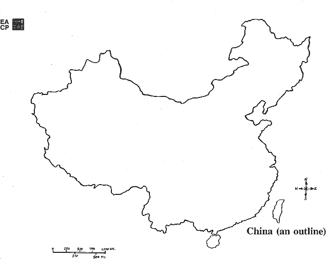
- Using the outline map of China, can you draw in:
(a) China's rivers?
(b) China's mountains and deserts?
(c)China's most important cities?
(d) a blue line indicating China's sea coast? - Water and rivers have always been very important in Chinese history. Can you tell why?
- What part of China would be best for
(a) traveling by camel?
(b) mountain climbing?
(c) finding high pasture lands? - What part of China would be best for
(a) plowing fields for crops?
(b) growing rice? - Looking at your map, where do you think most people would be likely to live? In the west of the China? The east? Why?
- What can you tell about a river that changes its course as the Huang He (Yellow River) has over the centuries? What sort of terrain would allow a river to change its course?
- Has China's size changed over time? When was it smallest? When was it biggest? What is it like today?
Population
- Is China the most populous nation in the world? What is the 2nd most populous?
- Where is China's most arable land?
- What areas of China are most populated? Is this related to arable land? Why?
- Which country has the larger land area, China or the United States?
- How do the most populated areas of China and of the United States differ?
Borders
- Have China's historical borders changed over time? If yes, how?
- Where were the earliest civilizations in China located? Why do you think people chose to settle in these places?
- What geographical features can be found on China's borders
- Is it easy to travel across China's borders in terms of the terrain?
- Why is China the core of East Asia?
- What countries in East Asia were particularly influenced by China? Why do you think some others were not?
Regions
- What is the difference between the western and eastern regions of China?
- Why is interregional trade important in China?
- Do the differences between the regions create problems for China?
Political Divisions
- How many provinces are there in China?
- What cities have provincial-level status in China?
- How many autonomous regions are there in China?
- What is a 'Special Administrative Region' (SAR)?
Geographical Features
- Why was China's early civilization relatively isolated from other early civilizations?
- When we say “relatively†isolated, what does that suggest? Were there ways in which it was not isolated? Can you give examples?
- What sort of terrain did the eventual route follow between early China and other civilizations?
- What are China's two major rivers?
- Why is the Huang He called a "yellow" river?
a) Why is this river called "China's Sorrow"?
b) What is loess? How is it useful for human habitation? - Chang Jiang (Yangzi River) referred to as China's "main street"?
a) In what part of China are the upper reaches of this river?
b) Why did the Chinese government build a dam in the area called "The Three Gorges"? - What kind of land surrounds the Zhu Jiang (Pearl River)
a) What is grown in this river's ecosystem? - Research questions China's rivers:
a) If you wanted to travel in China with a row boat, which river would you choose to go on an why?
b) Could you travel by boat from one river to another without going into the open sea or carrying the boat across land? Which parts of China would you see if you did this?
Supplementing Geography
The Great Wall
- Why would the Chinese want to build the Great Wall?
- Why build it where they instead of somewhere else?
- When were the first segments of the Great Wall begun?
- What is the Great Wall built out of?
- Did it serve its purpose?
The Grand Canal
- Why would the Chinese build canals?
- Why build them where they did?
- What was the purpose of the Grand Canal?
- When was the original canal built?
- Can it still be used today?
- How do you think the Great Wall and the Grand Canal were built? ? By hand? By machine?
- How many people do you think it would take to build a mile of the Great Wall or the Grand Canal?
- How fast could this mile be built?
- How would you get the people to work on such projects?
Terracing and Irrigation
- Why do people build terraces on hill slopes?
- How is water managed on terraced hill slopes??
Agriculture
- What crops do the Chinese grow?
- What is meant by "wet rice cycle"?
- Is there a relationship between the traditional methods used in the wet rice cycle and the size of the population in China? Can you explain it?
Research project: Plan a Trip to China
Plan a trip in China so that you can travel by boat, by train, by car, by foot, and by camel.
- Decide which parts of China would be best for each mode of transport. Imagine what you eat in the different regions you travel through.
- If you needed to talk with the local inhabitants, how many languages would you need to know?
- Would you need different clothes in different regions so as not to be too hot or too cold?
- If you stayed in the homes of the local inhabitants, how would these homes be constructed?
The consultant for this unit was Professor Ronald G. Knapp, Distinguished Professor Emeritus at SUNY New Paltz where he taught in the Department of Geography from 1968-2001, was Chairman from 1995-2001,and was a member of the Asian Studies Program. Professor Knapp is a geographer who specializes on China. He is author of numerous books, including Chinese Houses: The Architectural Heritage of a Nation with glorious color photos of houses. Floor plans of homes display the organization of various historical homes in China, including the childhood homes of Mao Zedong, Zhou Enlai, and Deng Xiaoping.