Physical and Human Characteristics of Places—EAST ASIA
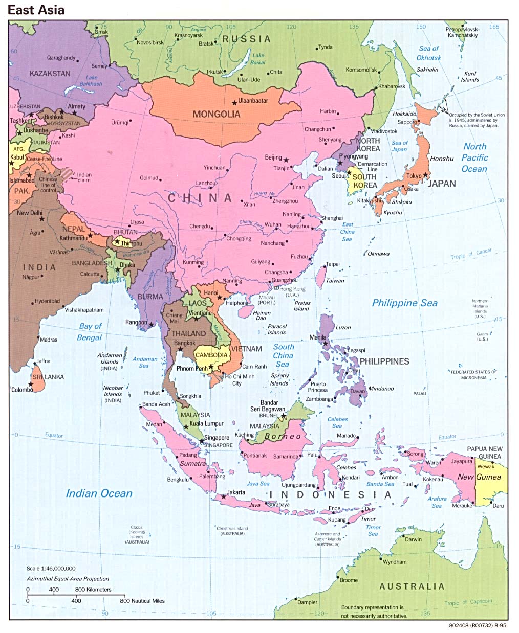
East Asia
• What is "EAST ASIA"? [Asia for Educators]
Is it just a directional name?
• Basic Points of Interest in the Geography of EA [Asia for Educators]
In looking at the complexity of East Asia, it is useful to keep in mind some of the basic points of interest that relate to people, places, and regions:
-
What is Asia? [Asian Art Museum of San Francisco]
"Asia" is a term invented by the Greeks and Romans, and developed by Western geographers to indicate the land masss east of the Ural Mountains and Ural River, together with offshore islands such as Japan and Java.
China
- China's Geography [Asia for Educators]
Provides a broad overview and excellent introduction to all aspects of China's geography, with maps and questions for discussion for each section. NOTE: the entire unit can be accessed as one piece, with visuals, at the link above for instruction or can be given to students for study and response. Questions for Discussion guide students through the interactive unit
Mountains and Deserts of China [Asia for Educators]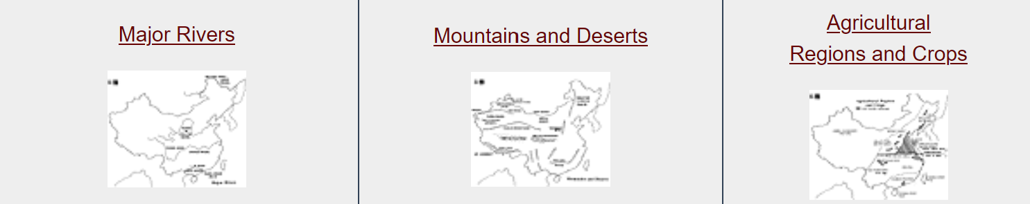
 The Major Rivers of China [Asia for Educators]
 Topography of China
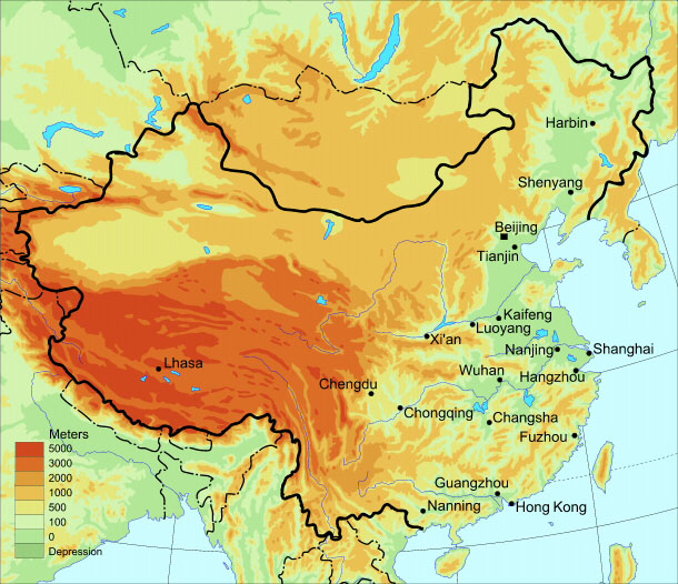 Elevation of China
 Arable land and Agriculture in China
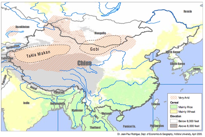
- Appreciating Chinese Place Names [Asia for Educators]
This unit offers an explanation of Chinese place names and can be used in conjunction with any map of Chiina's provinces to discuss how geographical features could be the origin of many provincial names, as well as city names.
- Ordering a Chinese Meal [Asia for Educators]
This exercise is designed to introduce students to Chinese cuisine and the variations in menu items chosen from different parts of China, influenced by geography and the agriculture it supports in particular areas.
- Arteries of Empire [Asia for Educators]
This reading for students discusses China's hydraulic (water control) system and important improvements over time in canal transport. The reading can be used to enlarge the discussion of the Grand Canal and China's use of waterways.
- Geography [A Visual Sourcebook of Chinese Civilization, University of Washington]
"Chinese civilization arose in a particular geographical context." A brief introduction followed by the following questions to consider while reading further:
- How did geographical location affect Chinese contacts with other early civilizations
- Through what kinds of different terrain did Chinese civilization spread?
- Why are minorities more common today in some areas than others?
- China's 22 Provinces [A Visual Sourcebook of Chinese Civilization, University of Washington]
With a separate map for each of the 22 provinces, plus two blank maps — one horizontal map and one vertical map — showing borders of China's provinces.
- Understanding the Geography of China: An Assemblage of Pieces [Asia Society]
This background essay introduces the diversity of China's natural and man-made features, as well as the relative population of its various areas. Used as background information, learners can explore the many different uses of maps (see related lesson plans).
- An Introduction to the Geography of China [Asian Art Museum of San Francisco]
Much of China, a country slightly larger than the continental United States, is hilly or mountainous. To its east lies the Pacific Ocean; to its south thick jungles. Learn more.
- What's in a Map? [Field Museum, Cyrus Tang Hall of China]
Students will analyze the many different maps in the Cyrus Tang Hall of China and draw conclusions about the purpose, audience, and potential bias in maps in general.
- There is no one China (interactive map of regions)
- China Through Time: Changing Borders (video)
- China Through Mapping [Annenberg Learner]
Mimi Norton teaches second grade at Solano Elementary School in Phoenix, Arizona. In this lesson, students learn about China's position on the globe and the location of important landmarks within the country. As a class, students create a giant map of China on the floor. Working in teams, students complete mapping tasks at classroom stations, focusing on the five themes of geography. As a culminating activity, students solve an interactive detective mystery created by Ms. Norton and work in small groups to solve problems based on their mastery of the map of China.
What Did Make the Chinese “Chinese”? Some Geographical Perspectives [Education about Asia]
Japan
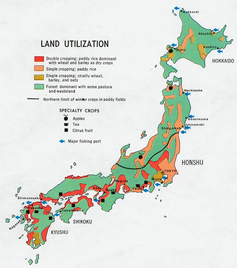
In learning about Japan's regions, one of the things to note is the way regional characteristics influence land utilization. [University of Texas Libraries]
-
Japan's Geography [Asia for Educators]
Provides an excellent overview for students.
Includes map exercises:
1. Japan: The Islands
2. Japan and Asia
3. Japan and California (comparison)
4. Japan and Italy (comparison)
5. Topography
6. Population Density
7. Latitudes / Japan and the U.S.
8. Winds and Currents
9. Japan: A quiz
Japan: Regions and Cities [Web Japan]
- An Introduction to the Geography of Japan [Asian Art Museum, San Francisco]
Part of a long archipelago off the eastern rim of the Asian continent, the island country of Japan has four main islands: Hokkaido, Honshu, Shikoku and Kyushu. Learn more.
- Exploring Japan's Geography through Visual Analysis [Asian Art Museum, San Francisco]
Students will: Build geographical awareness by identifying geographical features and resources that are specific to Japan; analyze how these features affected Japanese culture and econmic life; and develop argumentative responses utilizing their conclusions.
Japan Teaching Module: Geography Component 2: Centripetal Forces in Japan: The Physical Setting [University of Tennessee at Chattanooga]
-
Japan: Maps and Information [About.com]
Maps of Japan at the Perry-Castañeda Library Map Collection
[The University of Texas at Austin]-
Japan: Natural Hazard Risks [UN OCHA]
Korean Peninsula
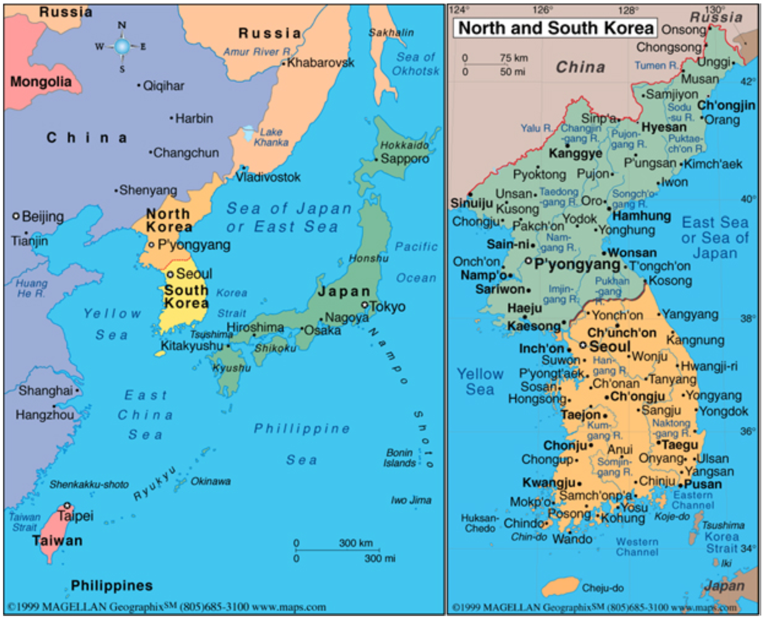
The Geography of the Koreas [Asia Society] provides an excellent introduction
 Originally from AskAsia, Asia Society
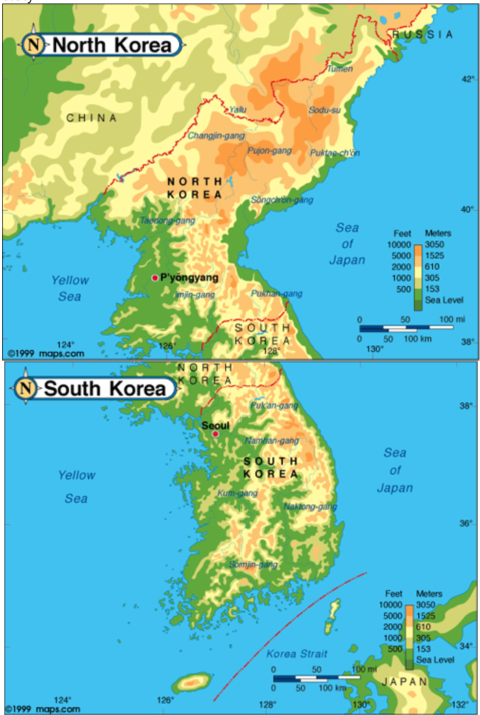 Originally from AskAsia, Asia Society
- Korea's Geography: How Do You Describe A Nation? [The Korea Society]
The purpose of this lesson is to introduce students to varying ways of seeing Korea's position in the world. Korea may be seen as "a shrimp among whales," as an "economic tiger," and as a notable tourist destination. Geography is not necessarily a static science, but one that can present changing views of a nation. This look at Korea also helps correct some inaccurate stereotypes of this major Asian nation. Lesson includes text, handouts, statistics, maps, and Web links.
-
The Geography of the Koreas [Asia Society]
A geographic exploration of North and South Korea, including its location, climate, production and how Korea perceives herself.
-
Korea: It's in the Bag [PDF] [The Korea Society]
For grades 4-6. In this lesson plan students will 1) identify the physical shape of the Korean peninsula; 2) label the physical and political features of the peninsula; 3) Draw conclusions as to how physical systems affect human systems.
-
Korea: Home Sweet Home [PDF] [The Korea Society]
For grades 4-8. In this lesson plan students will 1) identify the geographic regions of Korea used for human settlement; 2) analyze the physical systems and how they have affected the human life; 3) Explain how scarcity and choice have shaped the Korean culture.
-
Maps of Korea at the Perry-Castañeda Library Map Collection [The University of Texas at Austin]
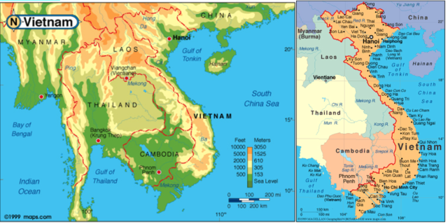
Vietnam
 Originally from AskAsia, Asia Society
-
Voyage to Vietnam: Geography [Children's Discovery Museum of San Jose]
Provides several maps of Vietnam and a comparison of Vietnam's size superimposed on a map of the United States.
Maps of Vietnam at the Perry-Castañeda Library Map Collection [The University of Texas at Austin]
-
Vietnam: What's in a Name? [Asia Society]
Vietnam had many names—and identities—over the centuries.
-
Vietnam: A Historical Introduction [Asia Society]
A short essay on Vietnam's geopolitical history, from pre-civilization times to the 21th century.
Regions as Conceptual and Organizational Units
What is a region?
A reasonable question. "Regions" are to geographers what "eras," "ages," and "periods" are to historians. Such terms are concepts that allow us to organize and identify periods of time and areas of space/place that share certain characteristics
Functional Regions
Functional regions are organized about a fixed point or node, such as a city, or connected via lines such as in a transportation system. Trade flows, commuting patterns, Internet networks, and communication systems are all mappable functional regions.
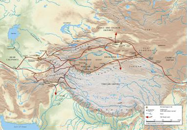
◦ The Silk Road
One important historical perceptual region can be loosely defined as all of the areas transversed by the fabled Silk Road. This region's intricate cultural character was woven together along trade routes
The Silk Road ultimately ran from Korea in the East to Rome in the West:
 A map in "From Silk to Oil" by the China Institute
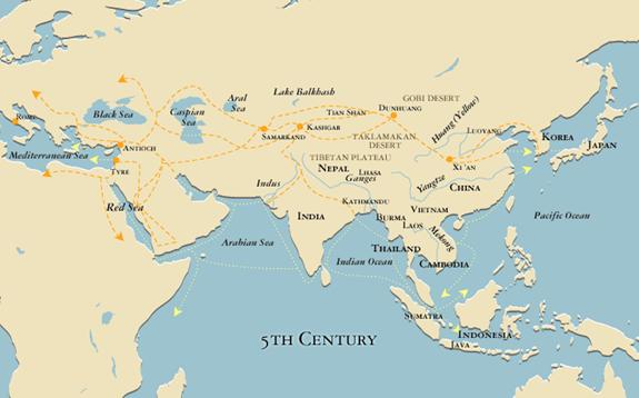 5th-century Trade Routes Map, Asia Society
- Maps of the Silk Roads, 1st Century to 15th Century [Journal of World History]
Maps from the article "The Indian Ocean in Eurasian and African World-Systems before the Sixteenth Century," by Philippe Beaujard, in Journal of World History 16, no. 4 (2005). Reprinted with permission.
-
International Dunhuang Project [IDP]
Website,features a wealth of information including numerous maps, photographs, and texts.
-
From Silk to Oil: Cross-cultural Connections along the Silk Roads [China Institute]
This teaching unit provides a comprehensive view along the Silk Roads, from the 2nd century BCE to the contemporary period. Supported by strong content essays and 23 curriculum units, the book, images, and maps provide a rich resource for teachers at several levels. The geography section of the book, Geography along the Silk Roads, is especially strong. Quizzes, exercises, and games are included.
-
Silk Road Seattle: Maps [University of Washington]
A very useful interactive map website developed to assist learners in mastering the basic geography of the Silk Road. Includes a useful section of interactive map exercises.
◦ China's Traditional Market Towns
"Marketing and Social Structure in Rural China," by G. William Skinner, in The Journal of Asian Studies. Recommended for faculty and advanced students only
Formal Regions
Individual countries comprise formal regions, as do areas of common religion or climate, or areas in which rice or fishing dominate. Each such formal region is defined by a set of criteria that is reasonably common or homogeneous across an area.
◦ East and Southeast Asia
-
The countries included under the formal regional term East Asia are — China, Japan, and North and South Korea, and Vietnam*
-
The countries included under the formal regional term Southeast Asia are — Laos, Cambodia, Vietnam*, Myanmar (Burma), Thailand, Malaysia, Singapore, Indonesia, and the Philippines. With the exception of Laos, the countries of both regions include coastal borders.
* Vietnam can belong to either or both formal regions. This is because the northern portion of what is now Vietnam participated in the civilization shared by what is now China, Japan, and Korea; the southern areas of Vietnam were more closely linked with the civilization shared by South Asia/India and its neighbors.
 East and Southeast Asia
◦ Regions of China
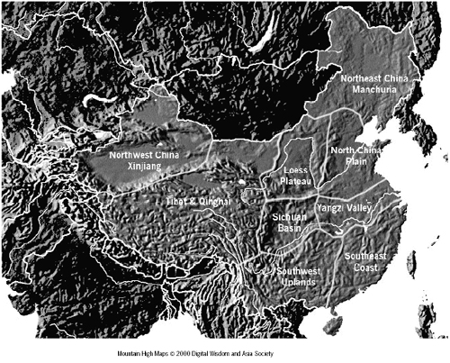
- Understanding the Geography of China: An Assemblage of Places [Education about Asia]
China not only has the world's largest population (over 1.3 billion), but it also is an extremely large country (more than 9.5 million square kilometers) with immense physical and cultural diversity. In fact, China should be viewed as an assemblage of pieces much like Europe. Anyone who tries to teach the geography of China faces the dilemma of either being very general (almost superficial) or delving into so many aspects and details as to be unable to complete the task in a single semester. How does one integrate three thousand years of history, language, local cultural practices, diets, architecture, et al. with basic physical geographies and economics that range from subsistence farming and herding to sophisticated electronics and computer industries in cities like Shanghai or Shenzhen?
All the regions mentioned in McColl's article are shown, except the Yunnan-Guizhou area, which is west of the southwest upland region.
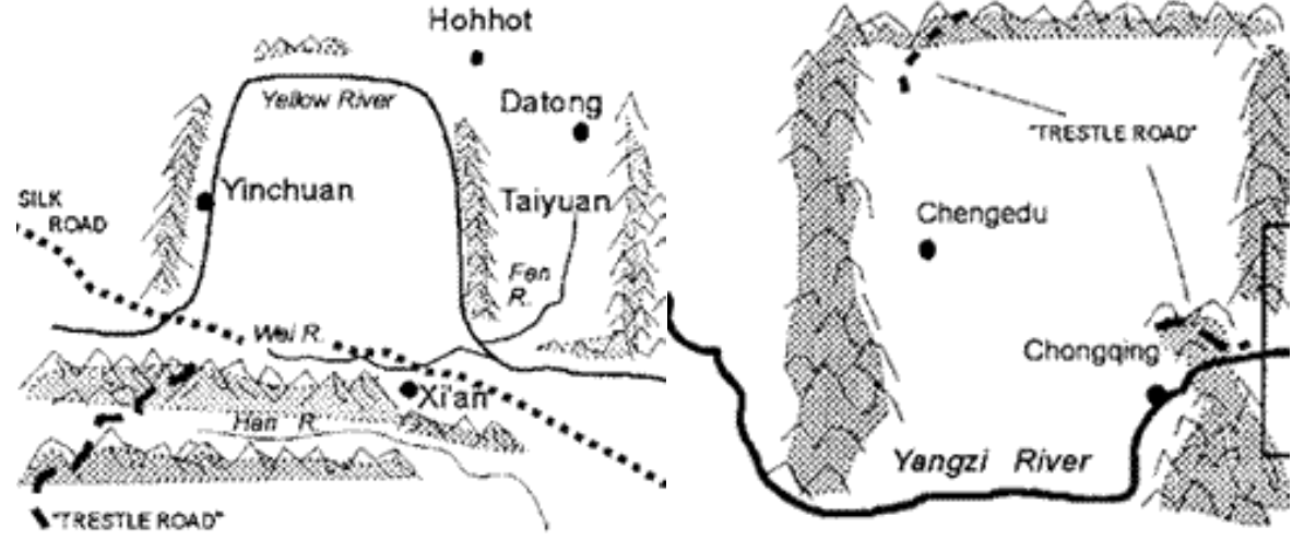 The Loess Plateu at left & The Sichuan Basin at right
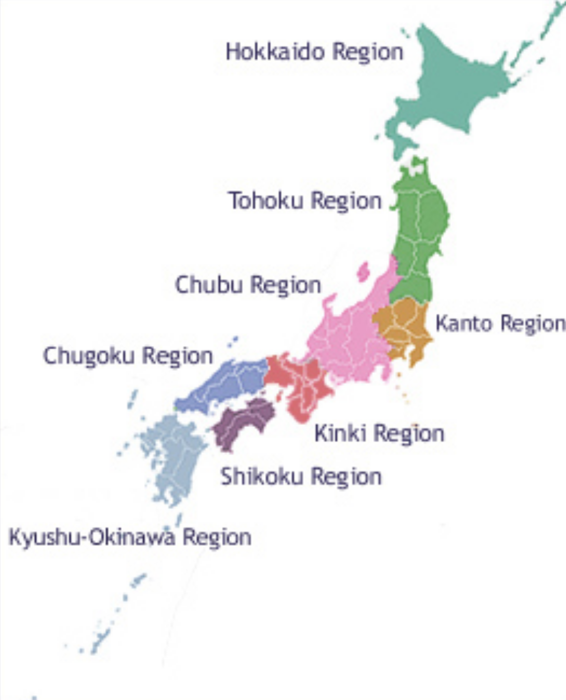
◦ Regions and Prefectures of Japan
-
Interactive map of Japan's regions, prefectures, districts, and cities [Web Japan]
With links to a travel website introducing each region [Japan Reference]:
1) Hokkaido: Hokkaido
2) Tohoku: Aomori, Iwate, Akita, Yamagata, Miyagi, Fukushima
3) Kanto: Kanagawa, Tokyo, Saitama, Gunma, Tochigi, Ibaraki, Chiba
4) Chubu: Niigata, Toyama, Ishikawa, Fukui, Gifu, Nagano, Yamanashi, Shizuoka, Aichi
5) Kansai: Shiga, Kyoto, Hyogo, Osaka, Mie, Wakayama
6) Shikoku: Tokushima, Kagawa, Ehime, Kochi
7) Chugoku: Tottori, Shimane, Yamaguchi, Hiroshima, Okayama
8) Kyushu: Saga, Fukuoka, Oita, Kumamoto, Miyazaki, Kagoshima, Nagasaki
9) Okinawa: Okinawa -
Regions of JAPAN [Kids Web Japan]
Interactive map site for younger students.